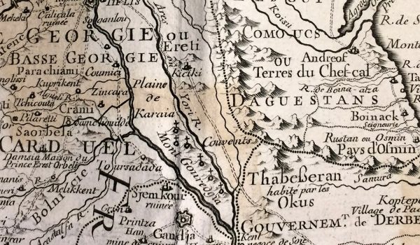
Giorgi Lobzhanidze, an expert on old maps and a member of the international map society has talked about the oldest map that shows Davit-Gareja monasteries (Mont Gouredgia) and the Karaia Valley, Mount Gareja, the outfalls of the Mtkvari and Iori Rivers within the boundaries of Georgia.
It was compiled by the French cartographer Guillaume Delisle and the Georgian writer and diplomat Sulkhan-Saba Orbeliani. The map, published in Paris, France in 1723, reveals the borders of Georgia with then neighboring countries: Shirvani and Ganja.
The Guillaume Delisle’s map is based on the cartographical material provided by Sulkhan-Saba Orbeliani and three French ambassadors to the shah of Persia. Then the cartographer himself added North Caucasia and the Caspian region to the map. One of the copies of the printed map is preserved at the National Centre of Manuscripts.
Georgia sent Sulkhan-Saba Orbeliani, to France and Italy on an urgent diplomatic mission in 1713-1716. Orbeliani handed the letter sent by the Georgian King Vakhtang VI to Louis XIV of France. It was probably during that time when he provided Guillaume Delisle with the cartographical materials.
source: www.Georgianjournal.ge
Photo: www.Georgianjournal.ge

